Autel
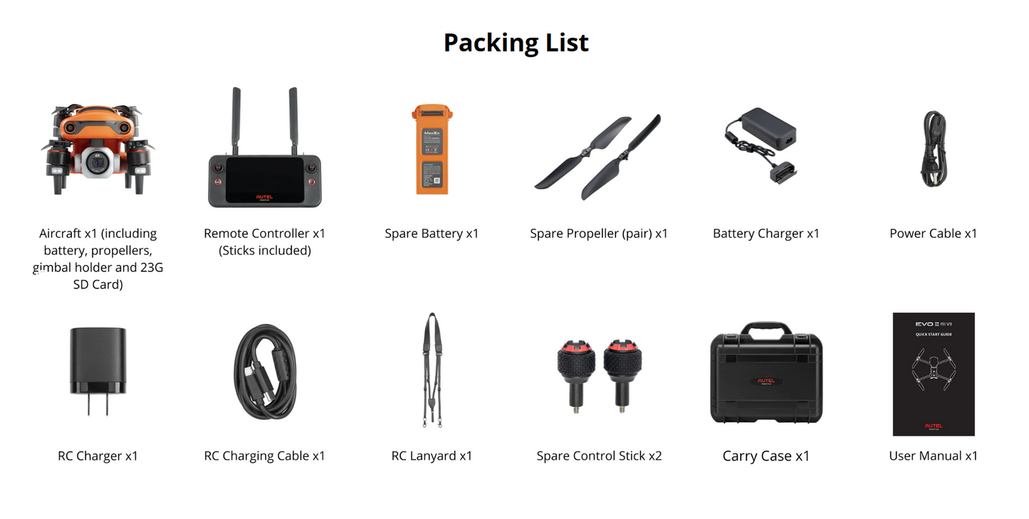
EVO II Pro V3 Rugged Bundle, 6K UHD Sony 20MP CMOS Camera sensor on 3-axis Gimbal, 360° obstacle avoidance, +9miles range
EVO II Pro V3 Rugged Bundle, 6K UHD Sony 20MP CMOS Camera sensor on 3-axis Gimbal, 360° obstacle avoidance, +9miles range
Regular price
$2,659.00 USD
Regular price
Sale price
$2,659.00 USD
Unit price
per
Shipping calculated at checkout.
Couldn't load pickup availability
The EVO II Pro V3 is a High-Quality Professional drone equipped with the Sony's new 20-megapixel 1" CMOS sensor capable of 6k Ultra HD Videos, and brings Object Tracking to another level with his Fast Object Tracking system. Its 19 groups of sensors grant it a 360° obstacle avoidance system.
Its 40minutes flight time plus over 9 miles of range on top of its 6k UHD camera make it suitable for professional video shootings with details and accuracy.
- Sony's new 20 megapixel 1" CMOS sensor capable of 6k Ultra HD Videos
- Adjustable aperture range of f2.8 to f11 and a maximum ISO of 44,000
- 12-bit DNG for post-production flexibility
- 360° obstacle avoidance with 19 groups of sensors
- Industry-leading 40 minutes flight time
- Transmission range of 12KM
- 6.4" Smart Controller SE
- 8GB Internal Storage + SD Card
- Fast Object Tracking
Specifications
Aircraft
| Takeoff weight | 1191 g |
| Max takeoff weight | 2000 g |
| Wheelbase | 397 mm |
| Size(L*W*H) |
230*130*108mm(folded) 457*558*108mm(unfolded) |
| Maximum service ceiling altitude | 7000 m |
| Max ascent speed | 8 m/s (Ludicrous) |
| Max descent speed | 4 m/s (Ludicrous) |
| Max horizontal flight speed | 20m/s (Ludicrous) |
| Max flight distance (no wind) | 25 km |
| Max tilt angle | 33° (Ludicrous) |
| Max angular velocity | 120°/s |
| Max flight time (no wind) | 40 min |
| Max hovering time (no wind) | 35 min |
| Operating temperature range | -10℃ ~ 40℃ |
| Maximum resistance to wind | Level 8 |
| Operating frequency |
902-928MHz (FCC Only) 2.400-2.4835GHz 5.725-5.850GHz (non-Japan) 5.650-5.755GHz (Japan Only) |
| Transmission power |
900M FCC/ ISED:≤31dBm 2.4G FCC/ ISED:≤32dBm SRRC/CE/MIC/RCM:≤20dBm 5.8G (non-Japan) ; 5.7G (Japan) FCC/ISED/SRRC/MIC:≤33dBm CE/ RCM:≤14dBm |
| Hovering accuracy |
Vertical: ±0.1 m (when the visual positioning is working normally); ±0.5 m (when GPS works normally) Horizontal: ±0.3 m (when the visual positioning is working normally); ±1.5 m (when GPS works normally) |
| GNSS | GPS/Beidou/Glonass/Gallieo |
| Internal storage | 8GB |
| SD storage | max. support 256GB (UHS-3 or Class 10) |
Gimbal
| Gimbal | 3-axis stabilization |
| Mechanical range |
Tilt: -135° to +45°; Pan: -100° to +100° |
| Controllable rotation range |
Tilt: -90° to +30°; Pan: -90° to +90° |
| Max control speed (Tilt) | 300°/s |
| Angular Vibration Range | ±0.005° |
Camera
| Sensor | 1 inch CMOS; 20M pixels |
| Lens |
FOV: 82° 35 mm format equivalent focal length: 29 mm Aperture: f/2.8 - f/11 Focus range: 0.5 m to infinity |
| ISO range |
Video: 100-44000 Photo: 100-6400 |
| Shutter speed |
Photo mode: 1/8000 ~ 8s Other: 1/8000 ~ 1/frame rates |
| Zoom | 1-16x (up to 3x lossless zoom) |
| Photo mode | Single shot/Burst shooting/AEB/Time Lapse/HDR |
| Maximum photo size |
5472*3648 (3:2) 5472*3076 (16:9) 3840*2160 (16:9) |
| Image Format | JPG (default) / DNG / JPG+DNG |
| Photo mode |
5472x3076P30/P25/P24 3840x2160P60/P50/P48/P30/P25/P24 2720x1528P60/P50/P48/P30/P25/P24 1920x1080P60/P50/P48/P30/P25/P24 |
| Video format | MP4 / MOV (MPEG-4 AVC/H.264, HEVC/H.265) |
| Max bitrate | 120Mbps |
| Supported file system | FAT32/exFAT |
Sensing System
| Sensing system type | Omnidirectional sensing system |
| Forward |
Accurate measurement range: 0.5-18 m Effective sensing speed: <12m/s Viewing angle: Horizontal: 60°, Vertical: 80° |
| Backward |
Accurate measurement range: 0.5-16 m Effective sensing speed: <12m/s Viewing angle: Horizontal: 60°, Vertical: 80° |
| Upward |
Accurate measurement range: 0.5-10 m Effective sensing speed: <5m/s Viewing angle: Horizontal: 65°, Vertical: 50° |
| Downward |
Accurate measurement range: 0.5-10 m Effective sensing speed: <5m/s Viewing angle: horizontal: 100°, vertical: 80° |
| Left and right |
Accurate measurement range: 0.5-10 m Effective sensing speed: <5m/s Viewing angle: horizontal: 65°, vertical: 50° |
| Operating Environment |
Forward, Backward and Sides: Surface with clear pattern and adequate lighting (lux > 15) Upward: Detects diffuse reflective surfaces (>20%) (walls, trees, people, etc.) Downward: Surface with clear pattern and adequate lighting (lux > 15) Detects diffuse reflective surfaces (>20%) (walls, trees, people, etc.) |
Remote Control & Transmission
| Operating frequency |
902-928MHz (FCC Only) 2.400-2.4835GHz 5.725-5.850GHz (non-Japan) 5.650-5.755GHz (Japan Only) |
| Transmission power |
FCC:≤33dBm CE:≤20dBm@2.4G,≤14dBm@5.8G SRRC:≤20dBm@2.4G,≤33dBm@5.8G/5.7G |
| Max Transmission Distance (unobstructed, free of interference) |
FCC:15km CE:8km |
| Display screen | 2340x1080 60fps |
| Battery | 1900mAh |
| Operating time |
~2 hours (Max. Brightness) ~4 hours (50% Brightness) |
| Charging time | 90 minutes |
| Internal Storage | ROM 128GB + expandable storage via micro-SD card |